Project abstract:
The Middle Fork Teanaway River (RM 3.2-5.4) Floodplain Restoration project area is in the upper portion of the Teanaway River Watershed, a tributary to the Yakima River in eastern Washington. The project is on public lands managed by the Washington Department of Natural Resources (DNR) as part of the Teanaway Community Forest (TCF) in Kittitas County. This report summarizes the technical basis of design for the restoration of river miles (RM) 3.2 – 5.4. The Washington Department of Fish and Wildlife (WDFW), Yakama Nation (YN) Fisheries, US Fish and Wildlife Service (USFWS), and NOAA Fisheries Biologists have developed an Aquatic Restoration Strategy that identified priority streams for protection and restoration in the Teanaway River watershed. The Mid-Columbia Fisheries Enhancement Group (MCF) and YN have been working with state agencies and local and regional stakeholders to restore aquatic habitat in these priority streams throughout the Teanaway. The North Fork (NF) Teanaway sub-basin was initially prioritized, and assessment and restoration actions were conducted between 2015-2022. Restoration activities by MCF, WDFW, and YN are now expanding to include the Middle Fork (MF) and West Fork (WF) Teanaway Rivers. Technical guidance, design reviews, and feedback for restoration activities are provided by the Teanaway Forks Restoration Steering Committee, which includes stakeholders, land managers, permitting agencies, and funding agencies.
Project goals:
The goals for the project are aligned with the broader restoration goals for the MFTeanaway within the TCF which include:
- Increasing and improving available fish habitat for focal species (Spring Chinook, steelhead, and bull trout) by increasing perennial channel length, pool frequency, gravel retention, and cover
- Enhancing natural water storage (slowing surface water runoff and increasing alluvial groundwater storage) to augment summer baseflows
- Improving and/or increasing wetland habitat
- Increasing floodplain connectivity and frequency of engagement
- Increasing hyporheic flow pathways to improve stream temperature
- Improving stream habitat suitability for beaver
- Utilize process-based restoration methods that encourage dynamic and self-sustaining riverscape conditions
Project plan:
Alternative 1: Valley Floor Reset to Stage 0. The first alternative included a valley floor reset to Stage 0 conditions. Restoration to Stage 0 is a valley-scale, process-based approach that aims to reestablish depositional environments to maximize lateral and vertical connectivity at base flows, and facilitate the development of dynamic, self-forming, and self-sustaining wetland-stream complexes. A Stage 0 condition has a well-connected alluvial aquifer and surface water expression throughout the valley floor. A project site restored to this condition can develop multi-thread channels, single-thread channels, no channels, or any combination in between while maintaining a well-connected alluvial aquifer. Depending on the geomorphic context, a valley-reset could be used to restore degraded sites ranging from fully fluvial river-wetland corridors to semi- or non-fluvial wetland/fen/peatlands. A valley-reset to Stage 0 involves filling incised channel(s) to create a valley-wide connected floodplain. The sediment needed to fill the incised channel is typically matched to bank and/or test pit stratigraphy and sourced from artificial features (levees, embankments, spoil piles, etc.), legacy deposits, fluvial terraces, or upland sources. LWM is strategically placed throughout the reconnected valley floor to create roughness and flow obstructions, trapping incoming sediment and forming a multi-threaded pattern that more closely resembles the pre-disturbance conditions. vegetation is established, and biological elements (vegetation, beavers, etc.) begin influencing the flow-field patterns, sediment routing, and channel development.
The second alternative includes a valley-reset to Stage 8 conditions, which is the restoration of a complex, multi-thread network within an inset floodplain at a lower base elevation than the Stage 0 surface (see Figure 4). This approach is typically employed where infrastructure or land use constraints limit full valley bottom reconnection. The valley reset approach would be very similar to Alternative 1, involving channel fill, floodplain grading, and widespread large wood placement. A Stage 8 target surface was not created as a part of this alternatives analysis, but this alternative was conceptually considered. Alternative 2 in this project area was assumed to include 50-80% of the earthwork and wood material quantities estimated from Alternative 1 resulting in approximately 105,000 CY of sediment redistribution and the placement of 4,500 wood pieces (LWM + racking) and 5,080 CY of slash material.
The third alternative includes large wood replenishment throughout the project reach. Under this alternative, LWM would be placed throughout the project reach as individual pieces (e.g. cut logs and rootwads) and in stable accumulations (e.g. engineered logjams). Large wood is a key structural element in forested stream ecosystems worldwide (Maser and Sedell 1994). LWM increases hydraulic roughness, creates diverse habitats, promotes sediment sorting and deposition, and influences lateral migration and anabranching. Wood loading in the project area has severely diminished over the last century due to historical impacts (see Section 2). Target wood loading metrics for Alternative 1 were determined utilizing Fox and Bolton (2007) 75th percentile metrics. To meet target metrics, Alternative 3 would include the placement of over 1,240 pieces of LWM including both key pieces with rootwads and non-key pieces. Additional racking wood and slash material would be incorporated into logjam structures. Note that these large wood quantities are far less than Alternatives 1 and 2 because the Fox and Bolton wood loading metrics are calculated at the channel scale, whereas wood loading for Stage 0/8 projects are calculated at the valley scale.
Valley-reset to Stage 0 was selected as the preferred alternative through a comparison of costs and benefits as well as discussions with the project partners, the steering committee, and the design team. Compared to Alternatives 2 and 3, Alternative 1 can better achieve the project goals and objectives under a much shorter timeline. Alternative 1 could immediately aggrade the channel and reconnect the T1 surface after a single intervention. The reconnected floodplain will result in lower stream power, with logjams and vegetated islands forming erosion-resistant hard points on the floodplain to retain placed wood within the project site and promote anabranching morphology. The alluvium cover over the exposed sandstone bedrock would be maximized throughout the project reach, effectively stopping the bedrock erosion process and minimizing the risk of continued channel incision. It is anticipated that the influence on natural water storage, hyporheic flow, and fish/beaver habitat suitability would be immediate and significant.
Project progress:
Project is currently at the 30% design phase.
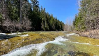
Project Photos:


Status: Active
04/18/2025 - PresentLead Project:
Activity:
Targeted Populations:
In partnership with:
Team:
Project Manager
-
Brandon Rossi ,
Habitat Biologist (YKFP)
509-831-3565