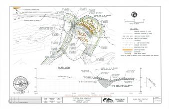
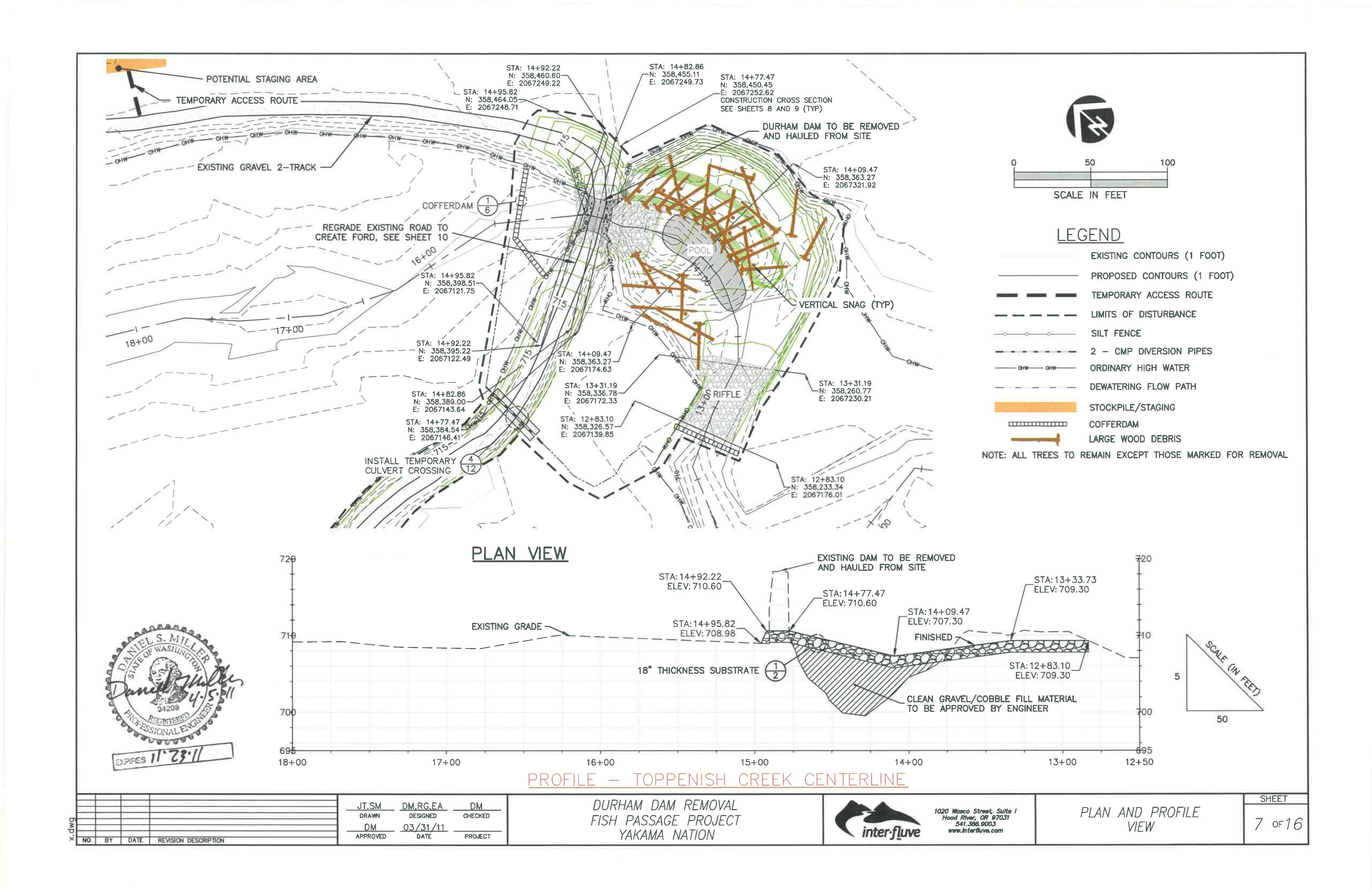
The factors limiting fish passage and habitat degradation at the Durham Irrigation Dam restoration site were the result of an obsolete irrigation diversion dam. This site is located at river mile five on Toppenish Creek. During periods of heightened instream flows, the confines of the dam abutments created a hydraulic pressure gradient, limiting successful fish passage. Another result of the heightened hydraulics was the creation of an extensive scour pool downstream of the dam, which lacks roughness elements necessary for utilization by multiple life history stages of Middle Columbia River steelhead. The upstream habitat adjacent to Toppenish Creek consists of wetland vegetation where, without the dams influence, a riparian corridor would likely exist. This factor has contributed to increased water temperatures, absence of fish refugia, a shift in primary macroinvertabrate production, and the absence of large woody debris/recruitment.
Yakama Nation Fisheries, Yakama Reservation Watershed Project (YRWP) concluded that removal of the diversion dam was the most effective method for achieving their goals of enhanced fish passage, and restoration of natural channel and floodplain processes. Large woody debris was installed just downstream from the removed dam, extending downstream of the crossing to protect/stabilize the left bank and create backwater fish rearing habitat. The riffle downstream of the pool was extended upstream and large woody debris was anchored to areas along the right bank of the pool to increase channel roughness. These measures will promote forage and rearing habitat for fish, while enhancing smolt and adult fish migration.
This project addresses many of the cumulative problems that are associated with the Yakima River Subbasin. The Columbia River Anadromous Fish Restoration Plan (CRAFRP) created by the Columbia River Intertribal Fish Commission, as well as the Yakima Subbasin Plan (YSBP), detail these problems and recommend actions to fix them. Temperatures in the lower Yakima River frequently rise to lethal levels during smolt migration. Restoring the riparian area at the site will aid in the reduction of cumulative temperature spikes downstream/river. Allowing the riparian corridor to restore and retain what is left creates potential for recruitment of large woody debris in this wood depleted system. Also, by removing potential passage barriers, the potential for fish production is increased. The largest runs of naturally reproducing populations of steelhead in the Yakima River subbasin are currently found in Satus and Toppenish Creeks. By following the recommended actions of the CRAFRP and YSBP for addressing the problems at the project site, the project will likely be successful in meeting the goals and objectives of the plan.
Remove hydraulic fish barrier, add grade control, and restore natural riparian condition.
- Remove diversion dam and enhance/restore 4.0 acres of floodplain and 0.3 miles of riparian habitat.
- Remove diversion dam and increase accessibility of Endangered Species Act (ESA) listed adult steelhead to 114 miles of stream, (Toppenish, Simcoe, Whatum, Agency, North Fork Toppenish, and Willy Dick Creeks) which includes all known spawning habitat.
- Remove diversion dam and increase accessibility of ESA steelhead smolts to 5.5 miles of Toppenish Creek.
- Add large woody debris with fabric encapsulated soil to create 6,682 square feet of backwater rearing habitat.
- Add large woody debris with fabric encapsulated soil to create 5,425 square feet of forage habitat.
- Add large woody debris with fabric encapsulated soil to stabilize 285 feet of stream bank.
- Create a roughened channel grade control riffle from scour pool tail spill through the existing dam location to enhance water retention and improve foraging habitat in area described above.
The construction phase of the project has been completed. Revegetation and vegetation maintenance by YRWP staff will be conducted until vegetation goals are met for the site. Upon removal of the coffer dams, the flow of water simulated a two-year flood event. The site responded as it was designed to, which allows for a heightened level of confidence in the projects long-term success and sustainability.


")
")
")
")